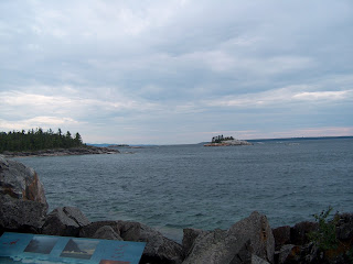
Anyway, this was where we were headed. Yes, that is Lake Superior, the largest freshwater lake in the world. Yes, it's cold. No, we didn't get our feet wet. This time! Yes, that is a very narrow rocky ledge that we had to walk out on in order to see the pictographs. Yes, it was scary. Yes, it was windy. Yes, the wind made you feel like you had to hug the rock cliff!

Interestingly enough, when we last visited the pictographs, we were not up close and personal. We walked out on these rocks
 and because we were farther away, the pictographs were pretty hard to see! I like the "up close and personal" version of 2008 much better. Yay for higher lake levels! But I get ahead of myself a bit.
This was the hike down toward the lakeshore.

Yikes, I really hope these rock walls don't move anytime soon, LOL. The rock wedged across the top is HUGE, and it's hard to see in the pic, but Lake Superior's waves are crashing into the opening and there is wave action up into the canyon.

Along the way, I noticed this moss-covered rock, with a blanket of ferns growing out of the moss! Interesting!

These are some of the small (and not-so-small, one of them has several houses on it) islands in Lake Superior, adjacent to the pictographs site. Some of the rocky outcroppings were believed by the First Nation People to be the shape of the spirit of the devils that controlled the lake.


And finally, the pictographs. We Had to climb down to the rocks at the base of the cliff, and then hug the cliff wall as we inched our way along to see the paintings. The paint was made from a mixture of ochre (from iron-rich rocks found on an island about 30 km away from the cliff) and animal fat. Sometimes it's hard to tell where a pictograph ends and the rock's natural red coloring begins. There are some non-descript red markings that look as tho once upon a time they may have been pictographs, but they have faded too much to know or sure.
DS6 sits next to two snake pictographs.

Pictograph of four canoes, probably commemorating a battle expedition in the late 1600s.

Another canoe.

Misshepezhieu, the devil spirit of the lake.

Horse and rider above a canoe and 4 discs, which are variously believed to be 4 suns, or that the chief who drew that pictograph belonged to the 4th order of the Midewiwin Lodge.

This was the path back out of the site. You didn't think the climb UP was going to be any easier than the climb DOWN, did you, LOL?

1 comment:
What an interesting area! Maybe I'll make it over that way someday.
Post a Comment